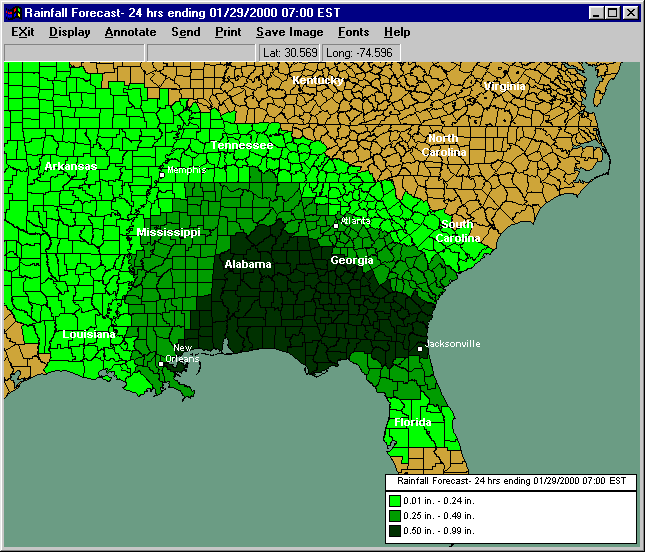
Hurrtrak Rainfall Forecast Capabilities
The HURRTRAK software coupled with HURRTRAK ONLINE allows the use to depict that latest National Weather Service Quantitative Precipitation Forecast (QPF) information. It can be displayed in either an "analysis" or a color shaded county thematic format. The QPF information is issued by the National Weather Services Hydrometeorological Prediction Center. Please note, while the QPF information does a good job of showing the location of "normal" precipitation amounts, it is not designed to forecast excessive precipitation amounts over a "small" area.
Some more information on the National Weather Services QPF "desk" is shown below (excerpts from http://www.hpc.ncep.noaa.gov/)
Quantitative Precipitation Forecasts (QPF)
The QPF desk prepares and issues forecasts of accumulating (quantitative) precipitation, heavy rain, heavy snow, and highlights areas with the potential for flash flooding. The basic QPF products are primarily directed to the NWS's forecast offices, but are available for anyone to use. The heavy snow forecast products, in association with the short-range public forecast products (described below), serve as a coordinating mechanism for the NWS's winter storm watch and warning program. Through a continuous watch for excessive rainfall, heavy snow, and winter storms, this desk ensures that the highest quality forecast products are constantly available.
The QPF desk is collocated with the National Environmental Satellite Data and Information Service (NESDIS) and together, they comprise the National Precipitation Prediction Unit (NPPU). NESDIS meteorologists prepare estimates of rainfall and current trends, based on satellite data and this information is used by the QPF short term forecaster as part of the input for individual 6-hourly forecasts that cover the next 12 hours. With access to WSR-88D/Doppler radar data, satellite estimates, and NCEP model forecast data as well as current weather observations and HPC analyses, the forecaster has the latest data for use in preparation of short-range precipitation forecasts. Meteorological reasoning discussions are regularly written and issued with the forecast packages to explain and support the forecast.
Short-Range (days 1 and 2) Public Forecasts
The primary aim of this forecast desk is to accurately depict the evolution of weather systems that will affect the continental U.S. during the next two (2) days. Forecasts are based on the subjective interpretation of the NWS's short-range computer models (namely the Eta, NGM, and the aviation model (AVN)). The short-range forecast package is issued twice a day on output from the 00Z and 12Z model runs. These forecasts predict the location and strength of fronts and pressure systems and the coverage and type of any precipitation every 12 hours out to two days in the future. These forecasts serve as the basis for the forecast maps that appear on many television weather forecasts across the country.
The Basic Weather forecaster is responsible for initiating reconnaissance flights whenever the potential exists for major winter storm development over the East and Gulf Coast states. These data gathering flights provide additional data for the forecasters and computer models to more accurately assess the pre-storm environment.