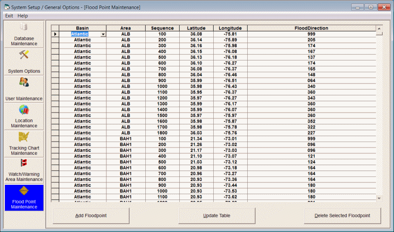
Flood point maintenance
This option allows the user to establish new or change/delete existing watch and warning points. The key fields are...
Basin - Basin identifies the hurricane basin that the floodpoint "coastline" is in. The Atlantic Basin is 1, East Pacific = 2, West Pacific = 3, N. Indian = 4, S. Indian = 5, SW Pacific = 6
Area - A Flood Point AREA groups together a contiguous series of geographical points. For example the US coastline is defined as one Flood Point area while the Puerto Rico coastline might be defined as another. I.E. There are no points that connect the 2 areas.
Sequence - The sequence number defines the sequence of geographical points within an area. To define an area from Texas to Maine as in the USA1 area, the sequence must be "in order" from Brownsville to Bar Harbour.
Latitude - This specifies the latitude, in decimal degrees, of the flood point defined.
Longitude - This specifies the longitude, in decimal degrees, of the flood point defined.
Flood Direction - The onshore flood direction for this flood point. I.E. The direction that flooding would "come from". The direction is defined by the compass where East is 090, South is 180, West is 270 and North is 360 (0 is defined as having no value). For most coastal areas, this direction would be perpendicular to the coast. For example, Miami would be 090 (east), Panama City, FL would be 200 (SSW), Galveston, TX would be 135 (SE), etc.. There are some cases, like inlets and bays where the flood direction (maximum flooding) is due to funnelling of water into the inlet or bay. Tampa Bay is an example of this where its maximum flooding occurs due to a SW flow.
The options available are:
To ADD a floodpoint, select the add floodpoint option.
To Change a point's information, make the required changes in the data table and select update.
To DELETE a floodpoint, highlight that row in the list and select the delete option.
The maintenance of the flood points areas is a rather complex one. Luckily there are only a few circumstance that require you to maintain this data set.
1. If you need to display the flood index for un-analyzed coastal areas. Although, we have "digitized" flood points for all of the large to medium sized coastal areas, including some inland lakes, we have not attempted to analyze every coastal area, like small islands. They present a special problem in that their onshore wind direction in reality is... "all directions". A storm surge coming in from the Southeast may inundate the entire island. You can however create a separate "flood" area for any island.
2. If you would like to modify the "digitized" flood points. Again, although we have digitized at a fairly detail level, your knowledge of local flood patterns like inlets, rivers, etc.. may make it desirable to add more detail to the coastal flood point pattern.
The database is organized sequentially by area and sequence number, latitude, longitude and onshore flood angle information. Click on the columns in the above graphic for a definition of each field. An ascending sequence within an area defines that area's coastline. In the sample above we see some of the flood points that define the coastline of North Carolina within the USA1 area. See the sample chart to get a better idea of how this looks for that area.
Example 1:
If you wanted to add Smith Island (Cape Fear) to the flood point data base your would need to add new records with a unique area name. For example:
Area, Seq,Lat, Long, Onshore Flood Direction
SMITH,1,33.88,-78.02,270
SMITH,2,33.89,-78,329
SMITH,3,33.9,-77.99,360
SMITH,4,33.89,-77.97,50
SMITH,5,33.9,-77.96,310
SMITH,6,33.91,-77.95,102
SMITH,7,33.89,-77.96,102
SMITH,8,33.87,-77.96,102
SMITH,9,33.86,-77.96,90
SMITH,10,33.85,-77.97,197
SMITH,11,33.86,-77.99,197
SMITH,12,33.86,-78.01,197
SMITH,13,33.88,-78.02,270
define the points for Smith Island. Once these are entered in to the database, Smith Island would then be included in the Flood Point analysis.
Example 2:
If you wanted to include Cape Fear Inlet (river) into the flood point data base your would add new records to the existing USA1 database. For example:
USA1,52700,33.98,-77.92,180
USA1,52701,34.07,-77.93,180
USA1,52702,34.12,-77.93,180
USA1,52703,34.15,-77.95,180
USA1,52704,34.19,-77.96,180
USA1,52705,34.17,-77.97,180
USA1,52706,34.12,-77.95,180
USA1,52707,34.04,-77.95,180
USA1,52708,33.99,-77.95,180
USA1,52709,33.94,-77.98,180
USA1,52800,33.9,-77.95,180
would be inserted into the database in the appropriate sequence. (I have made an assumption that a due South (180) wind flow would result in the largest flooding in Cape Fear Inlet.)
If you modify the flood point database, we would be interested in getting a copy of these additions or changes for possible incorporation into future releases.