Select Storm by Location
By far the most complex selection method, selecting a group of storms by location allows the user to do a very detailed analysis of how an area historically has been affected by storms and also do some real time comparison to a current storm situation. For example, you can see how many storms have passed within 60 miles of a latitude / longitude point that had winds greater than 74 MPH. Another example.. If there is a current storm moving through the Lesser Antilles, you can do an analysis showing all of the past storms that are "similar" in characteristics as this one.
The following fields are required:
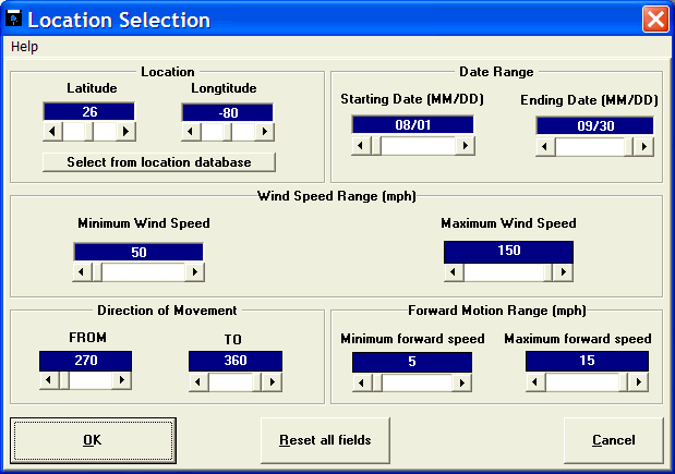
Latitude - The latitude of the location you wish to analyze. Be sure to enter this in degrees and tenths of a degree, not degrees and minutes. Northern latitudes are positive. You may use the "select from location database" function to have the system automatically find a locations latitude & longitude.
Longitude - The longitude of the location you wish to analyze. Again, this should be entered in degrees and tenths of a degree. Western Longitudes, like the Americas, are negative while Eastern longitudes are positive. You may use the "select from location database" function to have the system automatically find a locations latitude & longitude.
The following optional data fields are initially set to their widest ranges. If you wish to "narrow" the number of storms selected you may modify their values. They include:
Starting Date - The beginning date of the date range you wish to select.
Ending Date - The ending date of the date range you wish to select.
Minimum Wind Speed - The low end of the wind speed range. The unit of measure (UOM) used is determined by the user preferences as set in the tracking portion of the system .
Maximum Wind Speed - The high end of the wind speed range. The UOM used is determined by the user preferences as set in the tracking portion of the system.
Direction of movement - FROM - This represents the from azimuth value
Direction of movement - TO - This represents the to azimuth value.
Direction of Movement - The prior two fields define the direction of storm movement. The values are based off of a compass azimuth system where North is 0 or 360 degrees, East is 090, South is 180 and West is 270 degrees.
The direction of movement is defined from the FROM value clockwise to the TO value.
This is best explained with examples:
To select only storms that were moving to the NW, you would enter FROM - 270, TO - 360.
To select only storms that were moving to the North, you would enter FROM - 315. TO - 045.
To select only storms that were moving to the West, you would enter FROM - 225, TO - 315.
All of these examples, allows for a 90 degree wide range. In other words, for the East example, we will select all storm that were moving from the NE (045) to ones that were moving from the SE (135). If you want to narrow this range even further, you may do so. I.E. If you want storm that were coming from nearly due East, the FROM could be 080 and the TO could be 100 degrees.
This area is a little complicated, so it may be best to try different values and see the results.
Forward motion minimum forward speed - The low end of the range of storm forward motion speed. The unit of measure (KTS or MPH) is determined by the user preferences in the tracking part of the system.
Forward motion maximum forward speed - The high end of the range of storm forward motion speed. The unit of measure (KTS or MPH) is determined by the user preferences in the tracking part of the system.
(example of a selection where all of the fields described above are used)