Panning and Zooming
In addition to the Map Selection Tab of the Hurrtrak program, the following has to do with the Panning and Zooming capabilities in the SloshView, ModelPlot, Recon and Weather Observation modules of the system.
Mouse controlled map functions
are:
Moving Map -
The map area can be shifted by either using the scroll bars on the right and bottom
of the screen or by holding down the ctrl key and "hand"
moving with the left mouse bottom depressed. You may also move the
map using the scroll bars.
Zoom -
Zooming in can be accomplished by "rubber banding" area selection using
the left mouse button. The user can also use the "zoom
in" and "zoom out" tool icons.
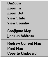
Right Mouse Click controlled functions are:
UnZoom - This option undoes the latest zoom in or zoom out.
Zoom In - This option changes the current map to a smaller scale
Zoom Out - This option changes the current map to a larger scale
View State - This option changes the current map to a scale what will fit the entire state currently in the map view. Note: If you are not within a state boundary (like in an ocean area), this function will display a blank map.
Configure Map - This option is a built in function of the mapping system and is not supported by PC Weather Products. You may experiment with the options displayed in the option as none of the changes made are permanent.
Lookup Address - This option allows the user to display a map centered on an address. Use street address, city state and zip.
Redraw Current Map - This option redisplays the current map
Print Map - This option is a built in function of the mapping system and is not supported by PC Weather Products. Use at your own risk.
Copy to Clipboard - This option will copy the current map to the windows clipboard. This is also a built in mapping system function. Do not confuse this with the copy to clipboard function that is available after displaying a storm track.