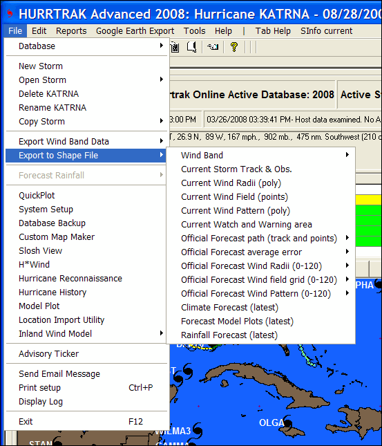
Export SHAPE Files
Hurrtrak
Advanced has the ability to export several types of storm graphic and report information
to an ESRI ™ Shape type GIS file. Graphic
type shape files for the currently loaded storm can be created by selecting
the FILE – Export to Shape File menu option.
The
data which can be selected includes…
-
Wind
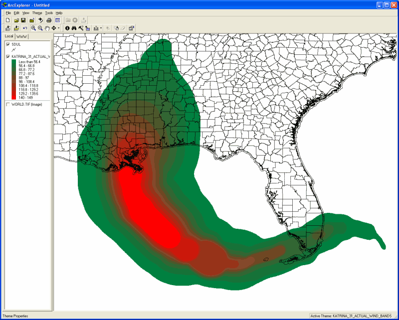
Bands (Polygon):
A polygon Shape file
containing the actual and/or forecast wind bands for a storm
-
Current
Storm Track and Observation (Polyline and Point):
This action creates
2 shape files… one that shows the actual storm track and a 2nd
Shape file containing a storm’s observation points.
-
Current
Wind Radii (Polygon):
This contains a polygon
type shape file that describes the wind radii of a storm’s 34, 50 and 64 knot
wind areas.
-
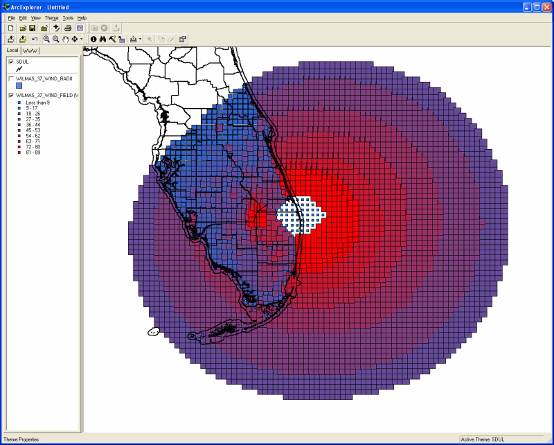
Current
Wind Field (Point):
This option creates
a point type shape file containing a grid of the current wind pattern across a storm.
The grid size is determined
via the GIS Export tab of the General User Options.
- Current Wind Pattern (Polygon): This option creates a polygon type shape file that includes the current multiple wind levels of a storm. Unlike the Wind Radii export, this can include up to 10 levels of wind.point type shape file containing a grid of the current wind pattern across a storm. The levels are is determined via the Wind Pattern Levels tab of the Plotting User Options. Advanced Wind Estimation (AWE) is not used in this export regardless of the AWE settings elsewhere. This is because AWE wind calculations would invalidate the concept of a polygon shape file format.
-
Current
Watch and Warning area (Polyline):
This creates multiple
polygon and polyline type shape files which represent the current tropical watches
and warning.
-
Official
Forecast Path track and points (Polyline and Point):
This action creates
2 shape files… one that shows the forecast storm track and a 2nd
Shape file containing the official forecast verification points.
-
Official
Forecast Cone (Polygon):
This action creates
a shape file that represents the forecast storm track cone of uncertainty.
-
Official
Forecast Wind Radii (Polygon):
This contains a polygon
type shape file that describes the wind radii of a storm’s 34, 50 and 64 knot
wind areas at a specific forecast hour.
-
Official
Forecast Wind Field grid (Point):
This option creates
a point type shape file containing a grid of the wind pattern across a storm at a
specific forecast hour.
The grid size is determined
via the GIS Export tab of the General User Options.
- Official Forecast Wind Pattern (Polygon): This option creates a polygon type shape file that includes the multiple wind levels of a storm for a specific forecast hour. Unlike the Wind Radii export, this can include up to 10 levels of wind.point type shape file containing a grid of the current wind pattern across a storm. The levels are is determined via the Wind Pattern Levels tab of the Plotting User Options. Advanced Wind Estimation (AWE) is not used in this export regardless of the AWE settings elsewhere. This is because AWE wind calculations would invalidate the concept of a polygon shape file format.
-
Climate
Forecast (Polyline) –
This option creates a shape file that represents the current climate forecast.
-
Forecast
Model Plots (Polyline) –
This option creates a shape file that contains multiple polylines which represent
the latest forecast model plots.
-
Rainfall
forecast (Polygon):
This option creates
several polygon type shape files.
One for each 24 hour
forecast period, out to 3 days, and also one each for 3 day total, 5 day total and
7 day total.
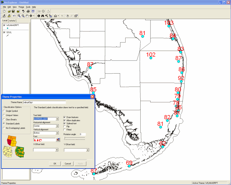
There
is one additional type of Shape file export which is associated with the Location,
County or Zip code impact report (example show below).
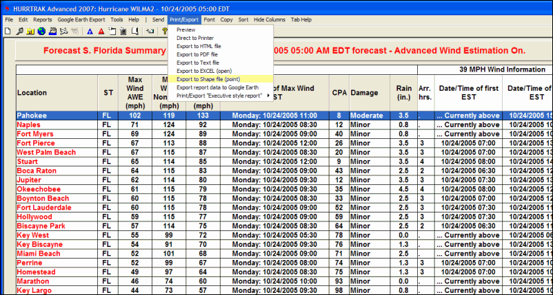
When
selected the contents of this report is exported into a Point type shape file.
Each point represents a row/location on the report and all of the report’s
data fields (max wind, date/time of Max Wind, etc.) are contained within the Shape
file.
All
of the exported shape files can be viewed/analyzed using your GIS software (separate
from HURRTRAK). While we do not recommend
or support any particular GIS software, you should be able to download ArcExplorer
for free from the ESRI web site.
Some
examples of data being displayed on ArcExplorer ESRI, are shown below.