Watch and warning area point maintenance
This option allows the user to establish new or change/delete existing watch and warning points. The key fields are...
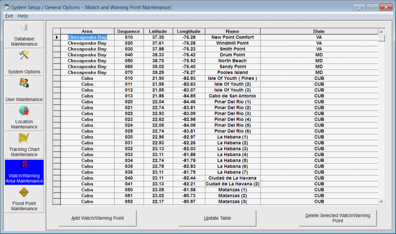
Area - Watch and warning AREAS group together a contiguous series of geographical points. For example the US coastline is defined as one watch and warning area while the Puerto Rico coastline might be defined as another. I.E. There are no points that connect the 2 areas.
Sequence - The sequence number defines the sequence of geographical points within an area. To define an area from Texas to Maine as in the USA area, the sequence must be "in order" from Brownsville to Bar Harbour.
Latitude - This specifies the latitude, in decimal degrees, of the watch and warning point defined.
Longitude - This specifies the longitude, in decimal degrees, of the watch and warning point defined.
Name - The name field contains the watch and warning points name. If this is blank then this point represents a "curve" in the coastline.
State - The state field contains the watch and warning points state or county code information. If this is blank then this point represents a "curve" in the coastline.
The options available are:
To ADD a watch/warning point, select the add watch/warning point option.
To Change a point's information, make the required changes in the data table and select update.
To DELETE a watch and warning point, highlight that row in the list and select the delete option.
The maintenance of the hurricane watch and warning areas is a rather complex one. If you are only interested in watches and warnings along the US coast and the National Hurricane Center does not deviate from their "standard" set of watch and warning points, then you will never have to maintain this data set.
There are several circumstances where you will need to maintain this data set.
1. If you need to display the watches and warnings for non US coastline areas, you will need to predefine those watch and warning areas before using this feature. The National Hurricane Center does NOT use a standard set of watch and warning points for areas outside of the US so there is a potential to have to manipulate this information for each storm occurrence.
2. If the NHC uses a non standard location along the US coastline. For example if they specify Mobile, AL as an end point for an area of watch or warning, you will need to insert that location into the database. (The other option in this case is to simply specify the nearest standard location to Mobile.)
The database is organized sequentially by area and sequence number and contains latitude, longitude and location name information. Click on the columns in the above graphic for a definition of each field. An ascending sequence within an area defines that area's coastline. In the sample above we see the set of points that make up the coastline from Everglades City, FL to Key Largo FL within the USA area. The records that have a location name and state are the predefined NHC watch and warning points. The records in between those points represent the "curves" in the coastline in between the locations. See the sample chart to get a better idea of how this looks for that area.
Lets look at a couple of examples of how you could change the data set.
Example 1:
Let say the NHC decided to issue a watch or warning from Big Pine Key to Jacksonville. Since Big Pine Key is not one of the pre-defined points, you would have to insert Big Pine Key into this data set. By examining the above table, you could add that location in area USA with a sequence number of 4115.
Example 2:
If you wanted to create a watch and warning areas for all of Cuba you would have to define the entire coastline of Cuba and then specify the watch and warning locations that you will use. So you may define 25 points that roughly define the coast and then specify 10 geographical locations to be used as the end points of the watch and warning areas. The 25 points and 10 geographical location are just used as an example.
A separate area must be defined for each non contiguous watch and warning area. The standard watch and warning areas pre-defined with the system:
USA - Main US coastline
N Chesapeake - Northern Chesapeake Bay
S Chesapeake - Southern Chesapeake Bay