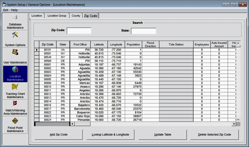
Location Maintenance - Zip Codes
This option allows the user to establish new or change/delete existing zip codes. The latitude and longitude values are the geographical center position of the zip code. Remember western longitudes are negative while eastern longitudes are positive. The Advanced & RM/Pro versions of the system uses the zip code information in its impact analysis.
Zip Code - This identifies the zip code
State - This identifies the zip code's state code (2 digits)
Post Office - This represents the post office city associated with the zip code.
Latitude - This identifies the zip code's geographical center latitude in decimal degrees. All latitudes north of the equator are positive and those south are negative. Latitudes for the North Atlantic and Eastern Pacific are positive. NOTE: DO NOT USE DEGREES AND MINUTES. To convert degrees/minutes to degrees and tenths of a degree, take the number of minutes, divide by 60 and add it to the degree value. I.E. 29 degrees 36 minutes is 29.6 degrees.
Longitude - This identifies the zip code's geographical center longitude in decimal degrees. All Western longitudes are negative while all Eastern longitudes are positive. Longitude values for the Atlantic and Eastern Pacific locations are negative. NOTE: DO NOT USE DEGREES AND MINUTES. To convert degrees/minutes to degrees and tenths of a degree, take the number of minutes, divide by 60 and add it to the degree value. I.E. -78 degrees 54 minutes is -78.9 degrees.
Population - This represents the population of the zip code. The system comes supplied with 2001 census data. Note: some population figures are 0 because they are not "inhabited" zip codes.. I.E. Post Offices.
Flood Direction - This identifies the direction that flooding typically occurs from. For example, in Miami a direct East wind (090 degrees) is the direction that flooding occurs. In Panama City, FL, the direction is more like SSW or 200 degrees. This is used in the detail location report when calculating onshore wind flow and the flood index graph.
Tide Station - This identifies the tide station associated with this county location. To associate a location to a tide station, click on this data cell. The user will then be presented with a tide station selection window.
Average Roughness Index - This represents the average roughness index for this zip code. This is used for the zip code wind impact report when Advanced Wind Estimation (for zip codes) is active (ON). This value has been pre-calculated and should be changed with care.
User defined field 1 - This represents numerical data that is defined by the user. In the example shown here, we picked data fields that may be on interest to the insurance industry. If you have a large quantity of user data that you would like to import into the database it may be best to use MS ACCESS to do the chore rather than hand data entry. Call PC Weather Products for assistance in doing this.
User defined fields 2-10 - This represents numerical data that is defined by the user as described above.
The options available from here are:
To ADD a zip code, select the add zip code option.
To Change a zip code's information, make the required changes in the data table and select update table.
To DELETE a zip code, highlight that zip code in the list and select the delete option.
Note: To find a zip code, use the search fields