
Fixed Tracking Chart Tab
Description:
This tab displays one of the many fixed area system tracking charts. These
include any custom maps created by the user. There are 3 "favorite"
tracking chart tabs available to the system.. one of which is a "multiple storm"
tracking chart. Many
storm tracking and analysis functions are available from here including
the ability to plot a track on a satellite image or
a radar plot.
Tab Created by: Always there when a storm is loaded unless specified otherwise by User General Options.
Tab Close Allowed: No
Functions Available:
Menu/Toolbar:
Standard System Menu Functions
Toolbars: See Appendix Section for more information.
Miscellaneous:
The
user can zoom in by rubber banding an area on the screen. Other pan and zoom options
are available by right clicking anywhere on the map image.
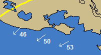
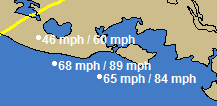
Left Clicking on a tracking map will display either the current wind vector (arrow) for the mouse position or the forecast wind speed for that location. This is controlled by toggling a toolbar button which is located on the primary toolbar.
![]() - In this mode, a left click will display
the wind speed/direction at that point, at the current time.
- In this mode, a left click will display
the wind speed/direction at that point, at the current time.
![]() -
In this mode, a left click will display the forecast wind speeds (sustained and gusts)
at the point.
-
In this mode, a left click will display the forecast wind speeds (sustained and gusts)
at the point.
Other:
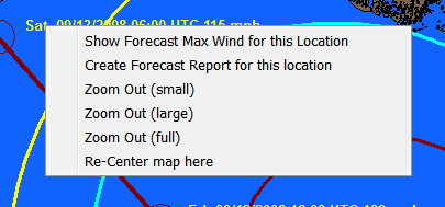
Point and Click Report - If you right click anywhere on the tracking map, near the forecast path, you have the option to create an impact report for that location.
Map list - This command will display the thumbnail sized images of all of the fixed tracking chart for your selection (dbl click). You can also select the chart from the dropdown list.
Satellite/Radar list – This command will display the thumbnail sized images of all of the satellite, sea surface temperature (SST) and Radar images that are available for overlaying storm tracks on top of. See example below
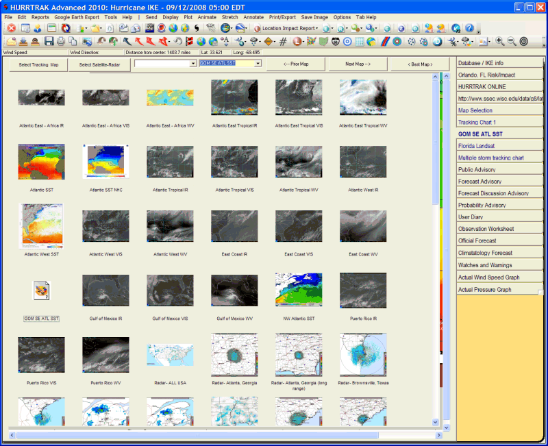
You can also select the image from the dropdown list. The selection of images is maintained by PC Weather Products and requires a HURRTRAK Online subscription to make active. Upon selection, the image is loaded from a 3rd party Internet source and then storm tracks may be plotted on top of it. Note.. Any plots that floods an area with color.. such as a forecast track error or wind band analysis will overlay the image behind it. It is suggested that you do not use these type functions. See example of a Satellite Image chart.
Next Map - This option will display the next (sequential) fixed area map
Prior Map - This option will display the prior fixed area map.
Best Map - This option selects the smallest scale map that has the storm's latest position on it.
Tips:
Using
the Next or Prior Map command buttons after being on the BEST map, will display the
first map in the sequence (full area map).
You can specify how many favorite tracking charts you would like to have available in the user general options.
The multiple storm tracking chart tab is special in that it is NOT refreshed when a new storm or database is loaded. This allows the user to plot more than one storm track on it.
The satellite image and radar drop down list is maintained via HURRTRAK Online and may change during the hurricane season. The images are downloaded from 3rd party internet sites which are generally very reliable.. but occasionally they may not be available.
The satellite and radar thumbnails are set to update via Hurrtrak Online every 3 hours. This can be controlled via the settings in general options. The age of the thumbnail has no affect on the image downloaded and displayed.. which is always the latest available.
Finally, since there are hours between NHC advisories, radar images will typically be for more current time than the hurricane observation data. i.e. Radar and hurricane data will not always be in sync.