CUSTOM MAP MAKER
Note:
While this original method of creating custom
maps is still supported, we recommend that you create your custom maps in a different
manner. Simply
select the “save as custom map” menu function available on the Map Selection
tab and the current image will be saved as a custom map.
See page 120 for more information on this.
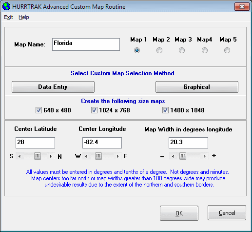
This option, accessible from the main program group or the tracking program, creates custom tracking charts (up to 5) that become integrated with the system. This feature is designed to compliment the predefined tracking charts and allows the user to create tracking charts specific to their area.
For more information on the various tracking charts available to the system, please review Hurricane Maps and Tracking Charts.
The data fields required to initiate the custom map creation are:
Map Name - The identifier for this map.
Map number - The number (1 to 5) of this map.
Center Latitude - The latitude of the center of the desired tracking chart. NOTE: North latitudes are positive while South latitudes are negative. Please enter in decimal degrees, i.e. 25.6, not degrees and minutes.
Center Longitude - The longitude of the center of the desired tracking chart. Western Longitudes, as in the US are negative and Eastern longitudes are positive. Please enter in decimal degrees, not degrees and minutes.
Map Width - The width of the desired tracking chart in degrees longitude. One degree of longitude is typically 60 statute miles (varies by latitude). This value can range from .1 (6 miles) to 100 (6000 miles) degrees wide. It is advised that you use this feature for smaller scale charts that complement the large number of charts that are included with the system.
NOTE: You may select the desired custom map area by selecting the graphical option instead of the data entry option.
Build County Database - If you are creating a custom map for the Atlantic basin, you may also build the database files that contain the county information for this specific chart. Select this option if you would like to do so.
Build Road Database - If you are creating a custom map for the Atlantic basin, you may also build the database files that contain the road information for this specific chart. Select this option if you would like to do so.
Show Rivers - If you are creating a custom map for the Atlantic basin, you may also show the major rivers for this specific chart. Select this option if you would like to do so.
NOTE: The selection of the road and county database creation add a significant amount of time to the creation process. It is advised that you don't select this option until you are satisfied that the custom chart area is what you desire.
Create 640 X 480 Chart - If you primarily use the smaller scale 640x480 pixel charts then select this option.
Create 1024 X 768 Chart - If you primarily use the large 1024X768 pixel charts then select this option.
Create 1400 X 1048 Chart - If you primarily use the large 1400X1048 pixel charts then select this option.
NOTE: Which size chart is used is partly determined by user selection in the general options and also by the desktop areas (pixels) being used by the user.
After you have entered the desired data field, select OK to create the custom tracking chart.
After the map has been created, you will be prompted to "Edit the chart". If you would like to do some color corrections to the tracking chart, select YES, otherwise select NO. This option is useful when certain portions of the chart like lakes and other bodies of water that were "cut off" by the edge of the chart did not turn blue and you would like to correct these before saving the chart. Clicking on the left mouse button will "paint" the selected area blue while clicking of the right mouse button will "paint" the area the "land color". A shift-leftbutton combination while moving the cursor slowly will draw a line. This is useful if minor changes or corrections need to be made to the coastline, etc..
When done, select the menu option "Finish".
When the map is finished, the county and road databases will be created if they were selected.