Location Group Summary Report Tab
Location Group Summary Report Tab
Description:
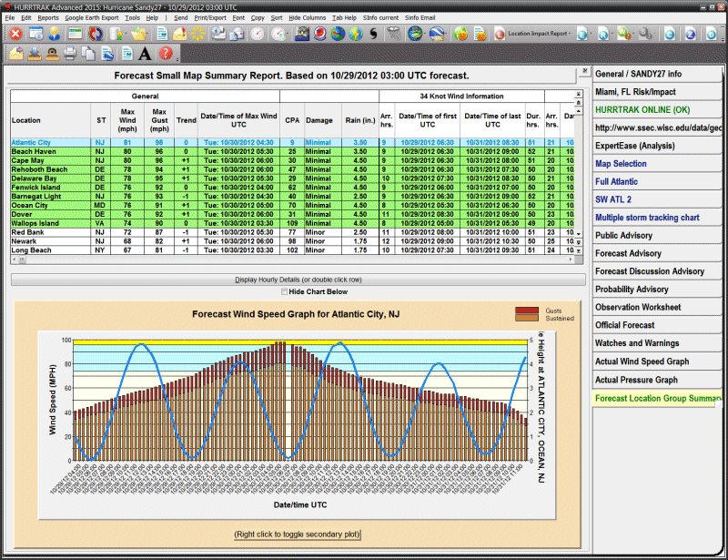
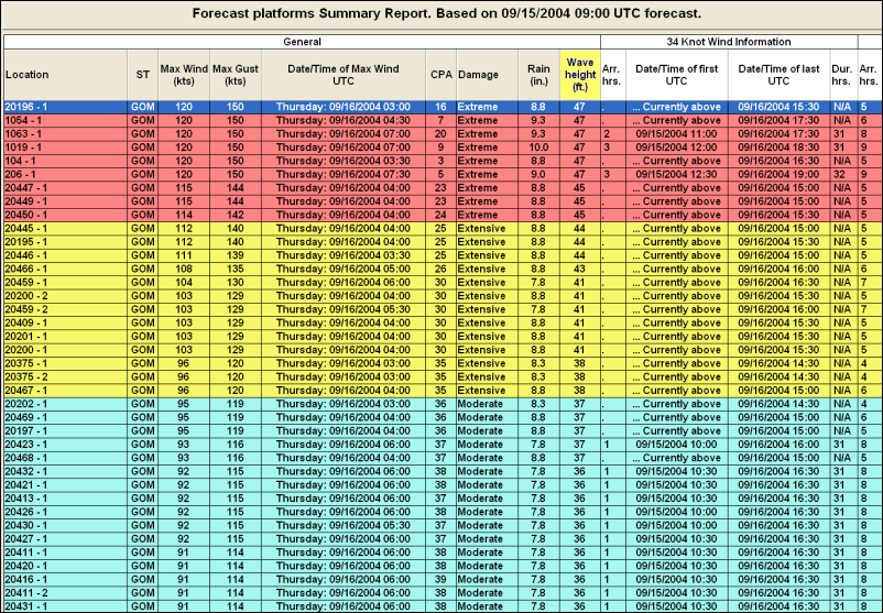
This tab displays the forecast or actual impact summary report for the
specified location group. It is generated by examining every location in the group
and determining the forecast wind impact to that location.
The
report shows the location name, state, maximum sustained wind speed expected, maximum
wind gusts, forecast wind trend, day/date/time of max sustained wind, closest point
of approach (CPA), damage estimate, forecast 5 day rainfall, watches and warnings
and the arrival time, first time, last time and duration of 34, 50 and 64 knot winds.
See National
Hurricane Center wind radii considerations for
more information on the limitations of forecast wind radii. Locations that have been
analyzed using Advanced Wind Estimation are indicated by their location name in red
and in the title of the report as well as including an additional column showing
the maximum non-AWE wind. See Advanced
Wind Estimation for more information. The
graph
portion shows the wind speed forecast over time along with the tide harmonic and/or
the wind direction.
The tide/wind secondary plot change be
cycled by left clicking on the chart.
Tab Created by: Selecting menu item Reports - Location Wind Profile (Forecast or Actual)
Tab Close Allowed: Yes
Functions Available:
Menu/Toolbar:
Standard System Menu Functions
Send - Sends the report via Email either as an HTML attachment or imbedded text
Print Preview - Previews the printed output on your screen
Direct to Printer - Prints the output directly to the designated printer
Export to EXCEL - Exports the output to Microsoft EXCEL format.
Export report data to Google Earth
Export report data to Google Earth with hourly details.
Print/Export "Executive Style Report"
Export to EXCEL with wind ranges - Exports the report to Microsoft EXCEL format with wind ranges for max sustained and gust (only enabled when AWE option is ON).
Copy - Copies the contents of the report to the windows clipboard.
Font - Allows the user to modify the text font properties for this report.
Sort - Allows the user to sort on any column.
Hide Columns - Allows the user to selectively hide certain columns
Display Hourly Details - This is selected by double-clicking on a location (row) or highlighting a row and selecting the "display hourly details" button.
Toolbars: See Appendix Section for more information.
Tips:
- The location report rows are color coded based on the maximum wind speed.
- Left clicking on the graph will change the secondary plot from wind to tide data (when appropriate).